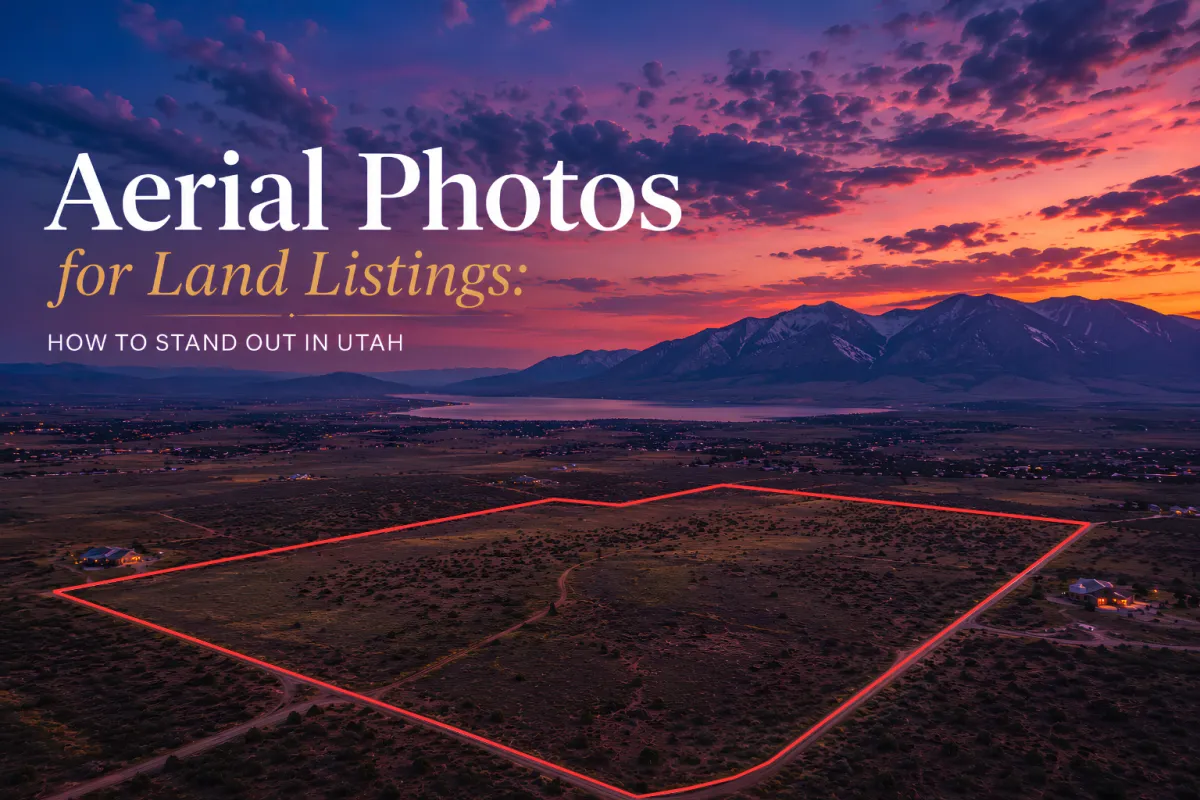
Aerial Photos for Land Listings: How to Stand Out in Utah
Real estate photographer Salt Lake City services using aerial photography to help Utah land listings stand out across Park City, Provo, and Ogden markets.
Real estate listings in Utah stand out dramatically when captured by a skilled real estate photographer Salt Lake City professionals trust, especially when aerial photography is used. Aerial photos reveal land scale, terrain, and surroundings in a way ground shots simply cannot match. In a market shaped by wide-open valleys, mountain backdrops, and fast-moving buyer interest, this visual edge becomes a serious advantage. From Salt Lake City’s urban edges to the scenic expanses near Park City and Provo, aerial imagery turns ordinary listings into scroll-stopping showcases. Utah’s varied terrain, shifting seasons, and dramatic elevation changes make drone photography especially powerful for land marketing.
Why Aerial Photos Transform Utah Land Listings
Aerial photography is one of the most effective tools for selling land in Utah because it reveals what buyers actually need to understand: scale, access, terrain, and surroundings. In Salt Lake City and surrounding areas like Draper and Sandy, properties often sit near mountain foothills or expanding suburban corridors. From the air, you can show proximity to roads, neighborhoods, and natural features like canyons or ridge lines.
Utah’s geography is visually complex. A flat parcel in Ogden looks very different from a sloped lot in Park City or a high-desert plot near Provo. Ground-level photos flatten these differences, but aerial views highlight them clearly. This is especially useful during spring listing season when buyers are actively searching and comparing multiple properties.
Weather also plays a role. Clear Utah skies, snow-dusted peaks in winter, and golden summer light over the Great Salt Lake all add emotional weight to listing visuals. Aerial shots capture these seasonal moods in a single frame, giving listings a storytelling advantage. For land investors, developers, and homebuyers, that clarity builds faster decisions and stronger interest.
How to Choose a Real Estate Photographer in Salt Lake City
Choosing the right real estate photographer Salt Lake City agents rely on means looking beyond basic camera skills. You need someone who understands drone operation, Utah terrain, and real estate marketing strategy all at once. Aerial photography for land listings is not just about flying a drone, it is about framing geography in a way that sells potential.
Experience across Utah’s regions matters. Shooting in Ogden’s river valleys is different from capturing hillside properties in Draper or luxury parcels in Park City. Lighting, wind conditions, and elevation shifts all affect image quality. A skilled photographer anticipates these factors and adjusts accordingly.
It also helps to work with professionals who understand listing platforms and buyer behavior. High-resolution aerial images should be optimized for MLS systems, social media previews, and marketing brochures. The goal is consistency across all channels so buyers get the same strong impression everywhere they see the listing.
In addition, equipment quality matters. Modern drones with stabilized gimbals and high-resolution sensors ensure crisp, detailed images even in challenging Utah wind conditions. Combined with editing expertise, this creates polished visuals that elevate land listings from simple posts to premium marketing assets.
Why Aerial Photography Gives You a Competitive Edge
In competitive Utah markets like Salt Lake City, Provo, and Park City, listings compete for attention within seconds. Aerial photography gives properties that crucial first impression advantage. Instead of guessing what a parcel looks like, buyers immediately understand boundaries, access points, and surrounding features.
This is especially important for vacant land. Without structures to photograph, traditional listings can feel incomplete. Aerial views fill that gap by showing the full context of the property. Whether it is a residential lot in Sandy or a large acreage near St. George, drone imagery communicates value instantly.
It also improves marketing performance. Listings with aerial visuals tend to generate higher engagement because they offer more information in a single image. This reduces uncertainty for buyers and helps agents move conversations forward faster.
For example, recent shoots at 3243 N 3500 W, Plain City, UT, 84404 and 1488 E Primrose Ln, Layton, UT, 84040 show how aerial perspectives highlight both land layout and surrounding development in ways ground photography cannot match.
Book Your Real Estate Photography Session
Strong visuals can turn Utah land listings into high-performing opportunities. If you want aerial photography that highlights terrain, access, and true property potential, working with a professional makes all the difference. Explore services and book your session here: https://utah.dmdrealestatephotography.com. From Salt Lake City to Park City and Provo, elevate your listings with imagery that captures attention instantly.
